
| 일 | 월 | 화 | 수 | 목 | 금 | 토 |
|---|---|---|---|---|---|---|
| 1 | 2 | 3 | 4 | 5 | ||
| 6 | 7 | 8 | 9 | 10 | 11 | 12 |
| 13 | 14 | 15 | 16 | 17 | 18 | 19 |
| 20 | 21 | 22 | 23 | 24 | 25 | 26 |
| 27 | 28 | 29 | 30 |
- rebuilderAI
- 3D모델링
- Rendering
- Digital Transformation in Real Estate
- startup
- 리빌더에이아이
- modeling
- #shoppingmall #fashion #game #mario #mariocart #vr
- 3Dmodeling
- Sod
- VR
- 3D
- VRIN3D
- nft
- Online Model Houses
- #meta #metaverse #spatialcomputing #xr #ar #commerce #3dmodeling #3d #sketchfab #modeling #rendering #ai #reconstruction #3dscan #3dscanning #3dscanner #generativeai #rebuilderai #vrin3d #vrinscan #vrinscanner #vrin3dscanner #vrin
- virtual
- AR
- 3Dscan
- 3D scanning
- PointCloud
- VRIN
- ai
- 3dmodel
- scanning
- 리빌더AI
- metaverse
- 브린
- scan
- Space
- Today
- Total
RebuilderAI_Blog
[3D Contents] The necessity of 3D scanning 본문

Chris Fisher, an archaeologist who appeared at Ted, is an expert who has done archaeological fieldwork all over the world. So, he thought he knew what to expect venturing into the jungle. But it was wrong. He picked the Mosquitia Rain Forest in Honduras as the most astounding place he'd been to, and contrary to his expectations that it would be hot because it was a rainforest, canopy of trees is so thick that sunlight never reaches the surface. In addition, unknown creatures brushed and pocked against the thin nylon fabric and were able to sleep through all the noise.
Chris Fisher aimed to study archaeology through an undocumented city, out of reach of the Earth. The Mosquitia rainforest in Honduras was a perfect place for the purpose. And there are still hundreds of places where people haven't stepped for centuries or maybe forever. But he didn't have much time to record all these places one by one. Since the climate crisis showed signs of destroying ecological and cultural heritage, Chris thought about how he could record all this before it was too late.
That all changed in July of 2009 in Michoacan, Mexico. He was studying the ancient Purépecha Empire, which is a lesser known but equally important contemporary of the Aztecs. Basic archaeological protocol is to find the edge of a settlement, so he set out alone on foot, expecting to encounter "the edge" in just a few minutes. Finally, he reached the other side of the malpais. And he realized that it was a huge city. It was an ancient urban megalopolis, 26 square kilometers in size, with as many building foundations as modern-day Manhattan, an archaeological settlement so large that it would take me decades to survey fully. In agony, he returned to Colorado and spoke to his colleague about problems. Colleague listened to Chris and asked if he had heard of the new technology called LiDAR - Light Detection And Ranging.
LiDAR involves shooting a dense grid of laser pulses from an airplane to the ground's surface. What you end up with is a high-resolution scan of the earth's surface and everything on it. It's not an image, but instead, it's a dense three-dimensional plot of points.
Chris asked for and received LiDAR data from the ancient Purépecha Empire, and over the next few months, he learned how to deforestation, removing trees, bushes, and other plants to see the ancient cultural landscape beneath them. In just 45 minutes of flying, the LiDAR had collected the same amount of data as what would have taken decades by hand: every house foundation, building, road, and pyramid, incredible detail, representing the lives of thousands of people who lived and lived and died in these spaces. And what's more, the quality of the data wasn't comparable to traditional archaeological research. It was much, much better.
Their work came to the attention of a group of filmmakers who were searching for a legendary lost city in Honduras. They failed in their quest, but they instead documented an unknown culture, now buried under a pristine wilderness rainforest, using LiDAR. They agreed to help interpret their data, which is how they found themselves deep in that Mosquitia jungle. In a month, they excavated over 400 objects from what we now call the city of the Jaguar.
They felt a moral and ethical responsibility to protect the site as it was, but in the short time things inevitably changed. Their initial LiDAR scan of this city of the Jaguar was the only record of this place as it existed just a few years ago. We can't study an area without changing in somehow, and regardless, the earth is changing.
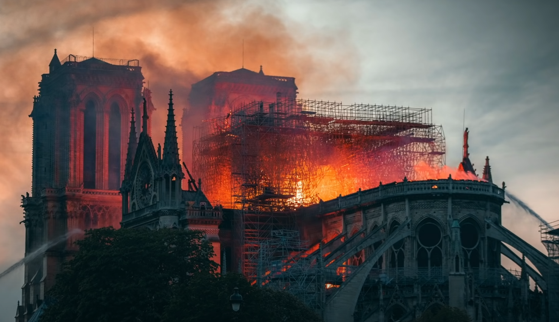
We watched in horror as the Norte Dame Cathedral went up in flames in 2020. The iconic spire collapsed, and the roof was all but destroyed. Miraculously, the art historian Andrew Tallon and his colleagues scanned the cathedral in 2020 using LiDAR. At the time, their goal was to understand how the building was constructed. Their LiDAR scan was the most comprehensive record of the cathedral, and it'll prove invaluable in the reconstruction. They couldn't have anticipated the fire or how their scan would be used, but we're lucky to have it.
Since then, Chris Fisher has felt the need to record the Earth through scanning. He thought it is necessary to scan the world with unprecedented scientific efforts. He has set three major goals, as shown below.
1) Create a baseline record of the earth as it exists today to mitigate the climate crisis more effectively.
Right now, we don't have a high-resolution before data set for much of the planet, so we can't measure change, and we can't evaluate which of our current efforts to combat the climate crisis are making a positive impact. However, recording the Earth through scanning technology will help prepare for the climate crisis more effectively.
2) Create a virtual planet so that any number of scientists can study our earth today.
Archaeologists like him can look for undocumented settlements. Ecologists can study tree size, forest composition, and age. Geologists can study hydrology, faults, and disturbance. The possibilities are endless.
3) Preserve a record of the planet for our grandchildren's grandchildren, so they can reconstruct, and study lost cultural patrimony in the future.
The Earth Archive is the ultimate gift to future generations because truth be told, I won't live long enough to see its full impact, and neither will you.
All these things are not easy, and they are not problems that can be solved quickly. But if we can record quickly with scanning, we can certainly break through any future crisis fast.
-
Original video: TED https://www.youtube.com/watch?v=B6rIUxHZ9f4
'3D Contents' 카테고리의 다른 글
| [3D Contents] About 3D Rendering #1 (0) | 2022.11.18 |
|---|---|
| [3D Contents] Cultural Heritage made of 3D scan (0) | 2022.11.08 |
| [3D Contents] 3D advertising that sensibly colored the world (0) | 2022.10.25 |
| [3D Contents] Virtual World of Meta (0) | 2022.10.18 |
| [3D Contents] The way to learn C4D easily (0) | 2022.09.22 |


